Tsamblak Hill
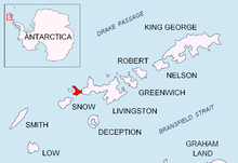
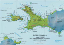
Rocky hill in the South Shetland Islands, AntarcticaTsamblak Hill is a rocky hill trending 900 m in north–south direction, 450 m wide and rising to 113 m in eastern Byers Peninsula on Livingston Island in the South Shetland Islands, Antarctica. It surmounts Bedek Stream on the east, Feya Tarn on the south-southwest and Eridanus Stream on the west.
Read article
Top Questions
AI generatedMore questions
Nearby Places

Urvich Wall
Narrow ice-free and crescent-shaped ridge in the South Shetland Islands, Antarctica

Sparadok Point
Sharp ice-free point in the South Shetland Islands, Antarctica

Camp Livingston (Antarctica)
Antarctic camp

Feya Tarn
Antarctic tarn

Eridanus Stream
Antarctic stream

Oread Lake
Antarctic lake

Montemno Lake
Antarctic lake

Bedek Stream
Antarctic stream


